Optimum Utilization of Iraqi Eastern Streams
Fouad Hussein Saeed (M.Sc.)
Iraqi Ministry of Water Resources,
Abstract:
In arid and semiarid regions, limited water resources is one of the constraints for agricultural activities and urban development. The eastern region of Wasit Province, Iraq suffer from a severe shortage of water resources especially the cities of Badra, Jassan and Zurbatiya. A few studies was focused on the streams that originate in Iraq-Iran borders such as Galal Badra, Tursekh and Swena as important source of water for domestic and agricultural use. This study was investigated the quality and quantity of water and better management of the streams which discharges into Shweicha Wetland. The Digital Elevation Models (DEMs) of Shuttle Radar Topography Mission (SRTM), the land use/cover of Landsat classified images by The National Geomatics Center of China, the soil dataset of Food and Agriculture Organization of UN (FAO), and the weather dataset of Climate Forecast System Reanalysis (CFSR) were applied into the Soil and Water Assessment Tool (SWAT) model, the model was ran for the period from 1/1/2000 to 31/12/2013 on daily time step of simulation. Due to lack in observed data such as flow or sediment the model was not calibrated with ± 20% error in prediction. From the results, the area of Shweicha Watershed is 21355 , 59.6% of this area inside Iraqi borders the remained in Iranian borders. According to the model prediction, the average income of surface runoff entered to Shweicha Wetland for the simulation period was about 5.5 with maximum peak of 5510 on 29/1/2013 and the simulated sediment yield from the region of study is highly related to the peak amount of surface runoff. The region considered, highly sediment production because the barren land dominate 43% of the total watershed’s area. Finally, it is recommended to store water before entered to Shweicha Wetland and find best way to prevent deposition in desired lake because store the water in Shweicha Wetland decrease the quantity and quality of water.
الخلاصة:
في المناطق الجافة وشبة الجافة، محدودية المياه تعد واحده من اهم العقبات في التنمية الحضرية والانشطة الزراعية. تعاني المنطقة الشرقية من محافظة واسط، العراق من شحة حادة في الموارد المائية خصوصا مدن بدرة وجصان وزرباطية. قلة من الدراسات تناولت الوديان التي تنشأ في المنطقة الحدودية بين العراق وإيران مثل كلال بدرة وترسخ وسوينه كمورد مائي مهم للاستخدام المنزلي والزراعي. في هذه الدراسة تم التحري عن نوعية وكمية المياه وأفضل طريقة لإدارة تلك الوديان التي تصب في منخفض الشويجة. بيانات نماذج الارتفاعات الرقمية (SRTM) وبيانات الغطاء الأرضي واستخدامات الأرض المنتجة من صور القمر الصناعي Landsat والتي تم تصنيفها في المركز الوطني للمساحة الصيني وبيانات التربة المنتجة من قبل منظمة الأغذية والزراعة ((FAO وبيانات الطقس المنتجة من النظام (CFSR) قد تم تطبيقها في نموذج SWAT للفترة من 1/1/2000 الى 31/12/2013. نتيجة عدم وجود بيانات مرصودة مثل التصريف او الترسبات لم يتم معايرة النموذج مع احتمالية ± 20% نسبة الأخطاء في التخمين. من خلال النتائج، بلغت مساحة جابية منخفض الشويجة بحدود 21355 كم مربع منها 59.6%داخل حدود العراق و الباقي داخل الحدود الإيرانية. طبقا لتخمين النموذج كان معدل التصريف الداخل لهور الشويجة خلال فترة المحاكاة بحدود 5.5 متر مكعب بالثانية مع اقصى ذروة بحدود 5510 متر مكعب بالثانية في يوم 29/1/2013 ونتيجة محاكاة انتاج الترسبات من منطقة الدراسة كانت متعلقة بشكل كبير بذروة السيح السطحي. تعد المنطقة ذات إنتاجية عالية للترسبات لسبب ان الأراضي الجرداء تشكل نسبة 43% من المساحة الكلية للجابية. أخيرا ينصح بخزن مياه الوديان محل الدراسة قبل دخولها الى منخفض الشويجة وإيجاد أفضل حل لتجنب طمر الخزان المنشود بالترسبات كون خزن تلك المياه في منخفض الشويجة يؤدي الى تقليل نوعية وكمية تلك المياه.
Introduction:
Water is the most important source for the municipal, domestic, industrial, and agriculture development (Masih et al., 2009). Scarcity in water resources in arid regions lead to deep investigation of available water resources and provide the optimum investment of these resources. In spite of availability of important water resources the eastern region of Wasit Province, the cities of Badra, Jassan and Zurbatiya suffer from a severe shortage of water. There are several streams originate in the borders of Iraq and Iran such as Galal Badra, Tursekh and Swena the water discharges from these streams to Shweicha Wetland. Most of water in Shweicha Wetland evaporate or discharges to Tigris River by Um Jury Channel. Recently, developments in integrated hydrological models and data availability by remote sensing, allow to building more spatial detailed and holistic models. These models able to predict the water quality, water quantity, climate, soil, land use/cover, nutrient cycling, and land managements in a coupled single system (Rouholahnejad et al, 2014).
There are three options to achieve optimum investment of water in region of study: Construction of small dams to harvest water in the upstream, discharging the water to the Tigris River from Shweicha Wetland, and storage the water in Shweicha Wetland. All above three options have big challenges, the challenge of the first option is difficulty of storing water in small dams because of the large amount of sediment income especially in the upstream, the challenge of the second option is a lot of losses of water during storage and discharge to the Tigris River in addition the reducing in water quality, the challenges of the last option are the risk of flooding Kut City from Shweicha storage and no economic income for this option.
The main objectives of this study are: evaluating the quantity and quality of income water to Shweicha Wetland and evaluate the optimum way for investment this source.
Methods and Materials:
- Study area:
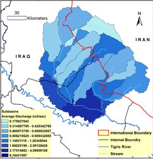
Shweicha Wetland is located in Wasit Province, about 5 km north east of Kut City. The watershed of Shweicha Wetland located between the coordinate of latitude 34° 13′ 88″ to 32° 31′ 15″ N and longitude 45° 0′ 11″ to 46° 54′ 45”, Figure (1). There are three major of water resources for Shweicha Wetland, Galal Badra, Tursekh and Swena also there are several of small streams originate in the eastern borders with Iran discharges the water to Shweicha (Al-Shamaa et al, 2012). The climate is characterized by cold and arid winter and long, dray summer with transitional seasons of autumn and spring. The mean annual rainfall for the period (1994-2006) was (212.62) mm, relative humidity was (44.01%), temperature was (24.56) C°, wind speed was (2.9) m/sec and evaporation from E-pan was (3162.72) mm. The maximum discharge of Galal River for (24) events used to determine the return period of flood for the river is (3500) m3 /sec (Al-Shammary, 2008).
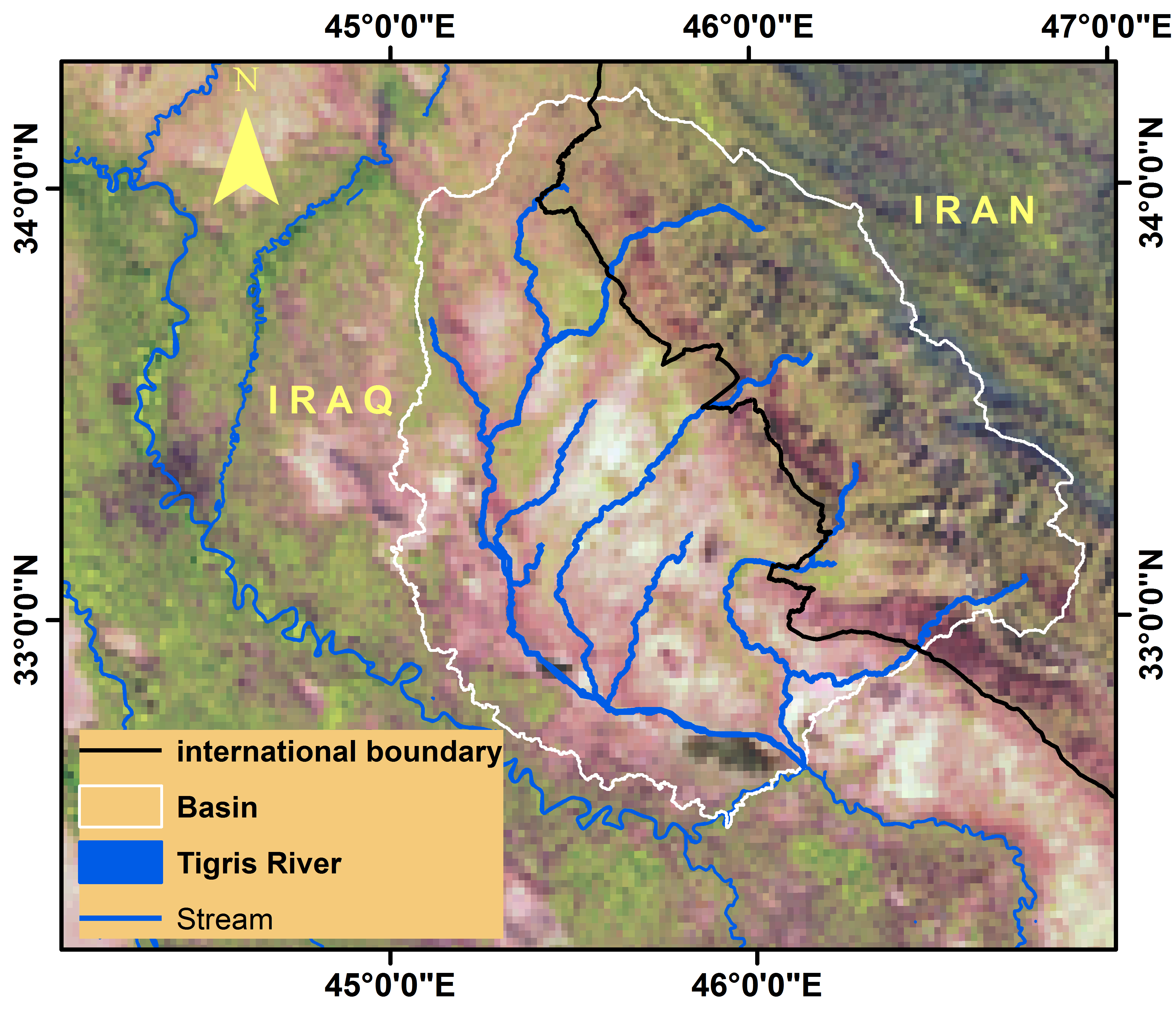
Figure (1): Location map for Shweicha Watershed
- SWAT hydrologic model:
SWAT is a physically based, long time of simulation macro scale hydrological model it’s developed in 1998 by U.S. Department of Agriculture (USDA-ARS) to simulate the surface runoff, sediment yield, soil temperature, nutrient movement and crop growth in agricultural watersheds under different land management activities (Arnold et al. 1998).
The simulation of surface runoff and sediment yield by SWAT, it requires inputs of DEM, soil dataset, Land Use and Land Cover (LU/LC), data and weather data. SWAT divides the catchment into multiple sub-basins based on the DEM data, which are further subdivided into Hydrologic Response Units (HRUs). The HRUs are lumped hydrologic units including of similar slope, soil characteristics and LU/LC (Gassman et al. 2007). The HRUs simplify to predict for the impacts of different soil properties, LU/LC, and management activities on the hydrological response of a watershed. SWAT processes the hydrological items such as surface runoff, sediment yield, evapotranspiration, and ground water flow take place at the HRU level and the water balanced for each HRU before flow routed to the reaches and streams of the sub-basins and then flow routed to the watershed channel. The volumes of surface runoff predicted in SWAT using the modified Soil Conservation Service (SCS) curve number (CN) method (Neitsch et al. 2000).
- Input data and its sources
DEM data: The Shuttle Radar Topography Mission (SRTM) DEM of (3-arc-seconds) or 90 m horizontal resolution was applied in SWAT in order to watershed delineation, determining of sub-basins and streams locations definition. SRTM DEM provides approximately all earth surface coverage of DEM with absolute vertical accuracy nearly 16 m. Recently, SRTM DEM of (1-arc-seconds) or 30 m horizontal resolution was obtained for all earth surface except the Middle East region (Jarihani et al., 2015). Two radars were produced the SRTM DEM: the first is the C-band (5.6cm-SIR-C,) by National Aeronautics and Space Administration (NASA) and the second is the joint of German Aerospace Agency (DLR) and, Italian Space Agency (ASI) (3.1cm-X-band) Synthetic Aperture Radar (X-SAR). Collected the earth surface DEMs by using single pass algorithms (Farr et al., 2007).
LU/LC data: The National Geomatics Center of China produced global land use/cover of (1-arc-seconds) or 30m horizontal resolution was applied in SWAT for HRUs definition. The images used for data creation of global land use/cove are basically multi-spectral images consisting the Landsat ETM+ and TM and the products of Chinese Environmental Disaster Alleviation Satellite (HJ-1) multi-spectral images. The cloud-less images were collected in vegetation growing seasons for the years 2009, 2010, and 2011. The overall accuracy assessment of images classification for global LU/LC for all classes was about 83.51%, the minimum 72.5% for shrub-land and the maximum 92% for water-bodies (Chen, 2014).
Soil data: The soil data of the Food and Agriculture Organization of the United Nations (FAO, 1995) were applied in SWAT for HRU delineations. The FAO soil dataset were collected from the earth soil map which provides the soil data for 5000 classes of soil in two depths (0 to 30 and 30 to 100cm from earth surface) at 1:5000000 of scale. The physical and chemical characteristics of soil such as available water, hydraulic conductivity, soil texture, bulk density and organic carbon for different depths of each soil type are available in FAO soil database. The FAO soil database was added to SWAT database and then lookup tables was created in order to classify the soil in SWAT.
Weather data: The Climate Forecast System Reanalysis (CFSR) weather dataset include forecasts of weather hourly, these data was produced by National Centers for Environmental Prediction (NCEP). Forecast models updated every 6 hours at 00:00, 06:00, 12:00 and 18:00 UTC using satellite derived weather and global weather stations network data. At any analysis hour, the CFSR depend for both the forecast weather data, predictive from the last analysis hour, and the data from analysis application to update the forecast models predictions. CFSR generates imaginary weather stations in 38km spatial resolution. This data consists historical prediction temperatures and precipitation for any location in the earth at each hour. CFSR provides weather dataset required in SWAT such as precipitation, minimum and maximum temperatures, solar radiation, relative humidity, and wind speed to simulate the surface runoff, evapotranspiration, etc. (Fuka et al., 2013).
- Model setup and calibration:
The input data was processed by ArcMAP 10.3, all spatial input data were projected to WGS 1984_UTM_Zone_38N, then applied on SWAT model and run the model for surface runoff and sediment prediction. The threshold sub-basin area was set on 100 yielding 19 sub-basins.
In this study, The optional modes were selected for the surface runoff and sediment yield simulations that consist: (I) The SCS-Curve Number (CN) method for runoff prediction (equations 1 and 2). (II) The Penman-Monteith equation to predict the potential evapotranspiration (ET). (III) The variable storage equation to simulate runoff and sediment routing (Neitsch et al., 2011). The other default parameters of SWAT were kept in its original values.
………………… (1)
…………………..(2)
Input parameters of SWAT model are be held within a realistic uncertainty range threfore it best to calibrate the most senstive hydrologic parameters due to this uncertain in these parameters. In the region of this case study there is no recorded data, so the prediction may related to ± 20% of error in prediction (Ma et al., 2000).
Results:
From the DEM based mothed used in SWAT model, the total watershed area of Shweicha Wetland is about 21355 , 59.6% of this area inside Iraqi borders the remained in Iranian borders, Figure (2). The average income of surface runoff entered to Shweicha Wetland for the simulation period is about 5.5 with maximum peak of 5510 on 29/1/2013 as shown in Figure (3). In addition, the results show no clear base flow in simulated streams and flow limited to peaks only.
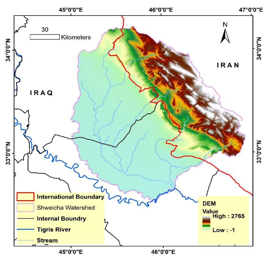
Figure (2). Topography of Shweicha Watershed
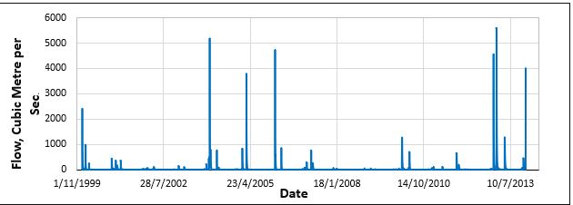
Figure (3). Simulated surface runoff income to Shweicha Wetland.
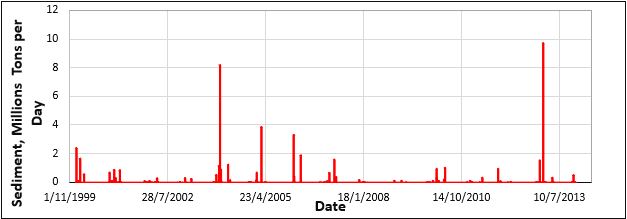
Figure (4). Simulated sediment income to Shweicha Wetland
For the simulation period the amount of surface runoff was divided into sub-basin level. Figure (5) illustrates that the maximum amount of surface runoff coming from the sub-basins inside Iraqi borders with 67% of total surface runoff entered to Shweicha Wetland. Also, the model was implemented for the sediment yield simulation. Figure (4) shows that the sediment yield in region of study is highly related to the peak amount of surface runoff with maximum amount of sediment yield with 9.7 million tons per day on 29/1/2013. The yield was concentrated in the most sharp slope and barren regions of the Shweicha Watershed as shown in Figure (6). From the Landsat images that classified by the National Geomatics Center of China that applied in SWAT model, the barren land and pasture dominate of 43% and 28% respectively, of the total area of the Shweicha Watershed. For this purpose the region consider high sediment production.
Finally, it’s recommended to store water before entered to Shweicha Wetland and find best way to prevent deposition in desired reservoir(s) because store the water in Shweicha Wetland decrease the quantity and quality of water due to large rate of evaporation and infiltration.
Figure (5). Surface runoff yield in sub-basins level of Shweicha Watershed
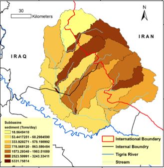
Figure (6). Sediment yield in sub-basins level of Shweicha Watershed
Conclusions:
From the results it can be concluded that Shweicha Watershed is a large and arid watershed and it’s consider as an important water supplier especially for the regions that suffer from water scarcity such as Badra, Jassan and Zurbatiya, the average discharge for the simulation period was about 5.5 as continuous water source. In additions, the watershed consider as highly sediment produces because the barren land and pasture dominate of 43% and 28% respectively of the total area of watershed so it should be careful in planning harvesting water dams.
The future study will be focused on the streams of Shweicha Watershed for hydrology (surface runoff and sediment yield) and topographic (available dam storage) and assessment of this streams as individual cases. Also, the future study will be simulate the effect of different land management on sediment yield.
References:
Arnold, J. G., R. Srinivasan, R. S. Muttiah, and J. R. Williams., (1998). Large area hydrologic modeling and assessment part I: Model development, J. Am. Water Resour. Assoc., 34(1), 73–89.
Chen L. (2014). 30-meter global land cover dataset (global land 30). http://www.globallandcover.com/GLC30Download/index.aspx.
Farr T. G., Rosen P. A., Caro E., Crippen R., Duren R., Hensley S., Kobrick M., Paller M., Rodriguez E., Roth L., Seal D., Shaffer S., Shimada J., Umland J., Werner M., Oskin M., Burbank D. & Douglas Alsdorf. (2007). The shuttle radar topography mission. http://www.geol.ucsb.edu/faculty/burbank/Site/Publications_files/Farr%20et%20al%20SRTM%20RoG2007.pdf.
Food and Agriculture Organization (FAO). (1995). The Digital Soil Map of the World and Derived Soil Properties. http://www.fao.org/soils-portal/soil-survey/soil-maps-and-databases/faounesco-soil-map-of-the-world/en/.
Fuka D. R., Walter M. T., MacAlister C., Degaetano A. T., Steenhuis T. S. & Easton Z. M. (2013). Using the climate forecast system reanalysis as weather input data for watershed models. Hydrlologic processes. 2013. DOI:10.1002/hyp.10073.
Gassman, P. W., M. R. Reyes, C. H. Green, and J. G. Arnold., (2007). The soil and water assessment tool: Historical development, applications, and future research directions, Trans. ASABE, 50, 1211–1250.
Issar M. Al-Shamaa ,and Batool Mohammad Ali., (2012). HYROLOGICAL RELATIONSHIP BETWEEN SURFACE AND GROUNDWATER IN BADRA – JASSAN BASIN. Iraqi Journal for Sciences, Issue 2, Page 335-340. Arabic Language.
Jarihania A. A., Callowb J. N., McVicarc T. R., Van Nield T. G. & J. R. Larsen., (2015). Satellite-derived Digital Elevation Model (DEM) selection, preparation and correction for hydrodynamic modelling in large, low-gradient and data-sparse catchments. Journal of Hydrology 524 (2015) 489–506.
Ma, L., J. C. Ascough II, L. R. Ahuja, M. J. Shaffer, J. D. Hanson, and K. W. Rojas. 2000. Root Zone Water Quality Model sensitivity analysis using Monte Carlo simulation. Trans. ASAE 43(4): 883-895.
Masih, I., Ahmad, M.-u.-D., Uhlenbrook, S., Turral, H., Karimi, P., (2009). Analyzing stream flow variability and water allocation for sustainable management of water resources in the semi-arid Karkheh river basin, Iran. Physics and Chemistry of the Earth, Parts A/B/C 34, 329e340.
Neitsch, S.L., Arnold, J., Kiniry, J., Williams, J., (2011). Soil and Water Assessment Tool Theoretical Documentation Version 2009. Texas A&M University System, College Station, TX, USA.
Neitsch, S.L.; Arnold, J.G.; Kiniry, J.R.; Srinivansan, R.; Williams, J.R., (2000). Soil and Water Assessment Tool: User’s Manual; Grassland, Soil and Water Research Laboratory, Agricultural Research Service: Temple, TX, USA, 2000.
Rouholahnejad, E., K. C. Abbaspour, R. Srinivasan, V. Bacu, and A. Lehmann., (2014). Water resources of the Black Sea Basin at high spatial and temporal resolution, Water Resour. Res., 50, 5866–5885, doi: 10.1002/ 2013WR014132.
Sarteel Hamid AL-Shammary., (2008). Hydrology of Galal Basin-Wasit-East Iraq, PhD thesis, University of Baghdad College of Science.