Climate Change Impacts: The Middle East and Iraq in Focus
Climate Change Impacts: The Middle East and Iraq in Focus
Nasrat Adamo1 and Nadhir Al- Ansari2
Abstracts
Global Climate Change has become a hot topic nowadays for the media, politicians and world organizations which have conflicting views on its extent and what to do to avoid its impacts. This paper attempts to check how real this change is and the historical evidence of its occurrence and describes its causes and what does this mean for Iraq. Iraq is located in one of the most vulnerable regions of the world and it has felt these effects in the forms of recurrent droughts, disturbed pattern of precipitation in the form of its quantity, intensity and timing, increased desertification and sand storms. This is also manifested by the diminishing of the water resources of both The Tigris and Euphrates Rivers whose catchment areas suffer the same impacts. The paper discusses also some of the performed modeling studies carried out so far to predict the future of these two rivers. The expected sea level rise is also explored and the future effects on Iraq’s Gulf shore line, its navel and land installations there and impacts on the deltaic region of southern Iraq explained. Other consequences of future climate change impacts are outlined in terms of water scarcity, farmland deterioration and migration of people with expected grave problems on the social peace. Some recommendations to mitigate and alleviate the situation are given.
Key words: Climate Change, drought, desertification, sand storms, sea level rise
Introduction
The subject of Climate Change has become nowadays a hot topic for the media and for lengthy discussions of the politicians in the various countries of the world. The focus of this change is global warming which has become so much noticeable everywhere. Much scientific studies and research have been conducted so far on the factors contributing to this warming and its contribution to disasters and deep environmental changes. Climate change can cause significant impacts on water resources and the hydrological cycle resulting in such things like the fast melting of the North and South Pole’s snowpack. The associated sea level rising, changes of the precipitation pattern over almost all parts of the world can also be mentioned. Other changes to specific regions fall within the framework of these changes and have become daily news on the media, such as unprecedented floods, violent tornados, recurrent hurricanes, severe droughts and loss of crop in addition to unprecedented sandstorms and desertification. Major sectors consequently shall suffer; such as agriculture, industry, human welfare and health sectors and development in general.
- Consulting Engineer and, Water Resources Specialist. Sweden
- Professor Laulå University of Technology. Sweden
Historical Evidence of Climate Change
Climate change is not a new phenomenon; Geological records have revealed the history of the planet’s climate to be a peculiar combination of both variability and stability. Global climate conditions have been favorable for human life and relatively stable for the past 10000 years and suitable for other forms of life for over 3 billion years. But geological evidence also shows that momentous changes in climate can occur in periods as short as decades or centuries (National Research Council, 2008). Richard Muller in his physics book (Muller, 2010) and (Muller et al 2007) discusses this mater and goes back into the history to give a brief account of global warming and traces it to the last major ice age about 12,000 B.C; when the average temperature of Earth was more than 10ºF colder than now (Fig.1). It shows also that agriculture was invented at the beginning of the current warm period about 8,000 B.C. (Fig.1). These findings were based on estimates from Greenland ice measurements of oxygen isotopes. The analysis of much later results based on accurate thermometer recordings from 1850 up to now, (Fig.2), indicates a rise in the average temperature of Earth amounting to 2ºF (about 1ºC).

Fig.1.Temperature from 12,000(BC) to the present from Greenland ice measurements of Oxygen isotopes (Muller 2010) (Muller et al 2007)
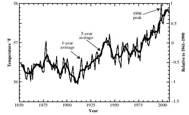
Fig 2: Earth average Temperature 1859 to 2006 (Muller 2010) (Muller et al 2007).)
Some people believe that the global warming is not caused by human activity, but is simply recovering from whatever natural phenomenon that caused the little ice age shown in (Fig.1). Climate change however was the subject of extensive studies and reports prepared by the Intergovernmental Panel on Climate Change (IPCC) which had confirmed that this phenomenon is actually due to human activities and the increased use of fossil fuel.
Causes of Global Climate Change
Climatic changes according to the (IPCC) may be due to natural internal processes or external forcing, or due to persistent anthropogenic changes. It does not rule out the possibility; that the rise from 1850 to 1950 was natural phenomenon, perhaps due to changes in the Sun; but the subsequent warming from 1957 until now is different. The (IPCC) issued its first report on these changes in 1990 and its fifth in 2013 (IPCC a 1990 – 2013). The definition of the World Meteorological Organization (WHO) states that this change refers to a statistically significant variation in either the mean state of the climate or in its variability; persisting for an extended period (decades) (WMO 1979). Climatic changes may be due to natural internal processes or external forcing or, to persistent anthropogenic changes. The (IPCC) qualifies this by adding “It is the change which may occur over the next century (21st) as a result of human activates in the composition of the atmosphere or in land use. (IPCC b 1990). The (IPCC) says that this warming was very likely caused, at least in part, by human activity and that most of the observed warming over the last 50 years is due to the increase in greenhouse gas concentration, and adds that discernible human influences extend now to other aspects of climate change, including ocean warming, continental-average temperatures rise, temperature extremes and the changes in wind circulation (IPCC. c .2007). In tracing the reasons for this rise in temperature scientific evidence attributes it to increased use of fossil fuel leading to increased release of carbon dioxide CO2. Research has shown that the concentration of CO2 has increased from a relatively constant level of 280 parts per million where it had been during the period from AD800 – AD1800 to the value of 380 parts per million in the last decade of the previous century: an increase of 36%. So, the warming phenomenon which is generally called the greenhouse effect is attributed to this increase the concentration of CO2 and some other related gases (GHS) in the atmosphere resulting from increased human activity. The four major gases forming the Greenhouse gas (GHG) are water vapor (36-70%), Carbon Dioxide (9-26%), Methane (4-9%), and ozone (3-7%). According to SRES ( Special Report on Emission Scenarios) for the greenhouse gas, the projections of the temperature at the end of the 21st century in the absence of any action to limit this emission range from 1.1ºC to 6.4ºC, compared to end of 20th century (IPCC, d. 2000 ). IPCC has defined six emission scenarios from 2000 to 2100 in the absence of additional climatic policies as shown in (Fig. 3). This figure indicates that the degree of severity of these Scenarios increases from the Scenario (B1) to Scenario (A1F1) (Zakaria 2013.).

Fig 3: Scenarios for GHG emission from 2000 to 2100 in the absence of additional climate policies, and projections of surface Temperature (Zakaria. 2013. )
The six IPCC six scenarios for GHG emission are described in brief as follows:
The A1 scenarios are of a more integrated world. The A1 family of scenarios is characterized by: Rapid economic growth, a global population that reaches 9 billion in 2050 and then gradually declines, the quick spread of new and efficient technologies, a convergent world – income and way of life converge between regions, extensive social and cultural interactions worldwide. There are subsets to the A1 family based on their technological emphasis: A1FI – An emphasis on fossil-fuels (Fossil Intensive), A1B – A balanced emphasis on all energy sources, A1T – Emphasis on non-fossil energy sources.
The A2 scenarios are of a more divided world. The A2 family of scenarios is characterized by: A world of independently operating, self-reliant nations, continuously increasing population, regionally oriented economic development.
The B1 scenarios are of a more integrated world, and more ecologically friendly The B1 family of scenarios is characterized by: Rapid economic growth as in A1, but with rapid changes towards a service and information economy, Population rising to 9 billion in 2050 and then declining as in A1, reductions in material intensity and the introduction of clean and resource efficient technologies, an emphasis on global solutions to economic, social and environmental stability.
The B2 scenarios are of a world more divided, but more ecologically friendly. The B2 scenarios are characterized by: continuously increasing population, but at a slower rate than in A2. Emphasis on local rather than global solutions to economic, social and environmental stability, Intermediate levels of economic development, less rapid and more fragmented technological change than in A1 and B1.
In predicting future climate change impacts on any region in the world, modeling studies are normally performed to forecast these changes to such a future time as the end of the 21st Century. Such studies may use one or more of the IPCC defined emission scenarios just described in its inputs and utilize one of the global climate models (GCMs). Other modeling procedures may even utilize some kind of hydrologic models such as the Max Plank Institute Hydrological model or one of the Regional Climate models for a climatic application (RCMs).
Climate Change and its impact on the Middle East
Global Climate Change is hitting all the regions of the world the Middle East and North Africa (MENA) region. The (MENA) land (Fig.4) extends from the Atlantic Ocean in the west to the Arabian Sea in the east, and from the Mediterranean Sea in the north to the (Africa Horn) and the Indian Ocean in the southeast.
Almost all of the (MENA) countries are located in semi-arid and arid regions that are highly vulnerable to climatic changes. Most of its countries depend on agriculture and oil for their economy; therefore they are vulnerable to any climatic variations, as well as any mitigation policy aimed at reducing oil dependence. (Zakaria 2013.).
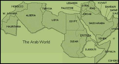
Fig.4: Map of the MENA countries
The region is influenced by its geographical location that increases the impact of climate change and most of the region is classified as hyper-arid, semi-arid and arid zones (Fig.5).
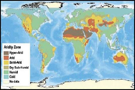
Fig.5: Aridity Zones of the World
Research Institute, reported that the total global emissions grew up 12.7% between 2000 and 2005, at an average of 2.4% a year. Emission of individual sectors grew at rates between 40% and near zero, and there is substantial difference in growth rates between developed and developing countries with different levels, but developed countries have the greatest share in emission growth (WRI 2005) (Fig.6) shows the regional distribution of greenhouse gases emission GHG) according to the same reference

Fig. 6: Regional distribution of the GHG emission of the world through the year 2000
Climate change affecting (MENA) region has many sides: First, it is markedly felt in the migration and changes in rainfall-dependent production systems and the fragile water resources regime; as the majority of rivers become variable rivers such as the Nile, the Euphrates, the Tigris (Turkey, Syria, and Iraq), and the Jordan and Yarmuk rivers- affecting recharging of aquifers in the region. Second, such changes will have their negative effects and undoubtedly lead to water shortages, droughts, loss of crop and increased potential for desertification. Finally, the other long-term implications such as the input on coastal areas, especially in Gaza, and Shat- Al- Arab (Iraq-Iran and Kuwait) could be devastating, (Trondalen, 2009).
The impact of sea level rise (SLR) is one obvious impact as a result of climate change. It is very likely that 20th-century global warming has caused an increase in the size of seas and oceans as well as loss of land ice (IPCC. e .2001). Through the period 1961-2003, it was observed that the global sea level rise was about 1.8 mm/year while during the period 1993-2003 it reached 3.1 mm/year (IPCC.f.2007). (MENA) countries are part of vulnerable countries to the impacts of SLR with different levels. Despite the fact that their coastlines will be under the impact of sea level rise, it will be more noticeable in countries that have deltaic areas, such as Egypt (Nile River delta) and Iraq (Tigris and Euphrates delta) (Fig.7). These two areas are the most vulnerable in (MENA) countries by sea level rise, (Ghoneim E. 2009).
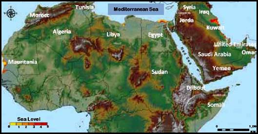
Fig. 7: Map showing the mostly affected areas in the MENA region by Sea level. This indicates Egypt (Nile River delta) and Iraq (Tigris and Euphrates delta) to be in the worst situation
Most of the Tigris and Euphrates water originate from South Eastern Anatolia is located within the Middle East and East Mediterranean climate zone (MEEM). This climate zone is part of (MENA) and it is affected by the same driving climate elements over it. So it is natural that the same climate change impacts are felt over it causing the reduction of the Euphrates and Tigris River water resources since this area contributes to the largest part of these resources. Long-term analyses of meteorological database (period 1901-2006) along with regional climate change model projections for the 21st century (Lelievld et al. 2012), suggests a continued and gradual and strong warming of the area of about 1-3ºC in the near future (2010-2039) to 3-5ºC in the mid-century period (2040-2069) and, 3.5-7ºC by the end of the century (2070-2099). Analysis of the annual precipitation database for the same period (1901-2006), projections showed a sharp decline of annual precipitation of 5-30% relative to the reference base period (1961-1990). In another study which employed an innovative super-high-resolution atmospheric global climate model, that accurately reproduced the precipitation and the stream-flow of the present day “Fertile Crescent” and projected the current trends in climate changes on the Middle East water resources till the end of the century, the results showed severe reductions of the annual discharges of the rivers in the region. The Euphrates River annual flow as one case might suffer a reduction of (29%-73%), as well as the stream flow of the Jordan River. (Kitoh et al 2008). In the wider picture of the Middle East the study showed that, by the end of this century, the “Fertile Crescent” (Mark 2009) would lose its current shape and could disappear altogether. (Fig 8) Another forecast indicated that today’s 100-year drought could occur 10 times more frequently in the future over the large part of the northern Mediterranean, while in North Africa, today’s 100-year drought will occur less frequently. (Weiß et al 2007).

Figure 8: The Historic Map of the “Fertile Crescent”. Mark (2009)
Both the Euphrates and Tigris rivers are fed by the melting of snow and rainfall in southeastern Turkey, northwestern Iran and northeast and east of Iraq. The flow of the rivers varies considerably every year, and destructive flooding is not uncommon, and conversely, years of low flow make irrigation and agriculture difficult. Figure (9) shows the catchment area of the Tigris and Euphrates and their tributaries in these countries. Their sub-basins are shown in Figure (10).The majority of water that flows through the Tigris and Euphrates Rivers’ basins originate from South Eastern Anatolia in Turkey which is part of the Middle East and East Mediterranean climate zone (EMME) and characterized by its climate; in more exact terms 80% of the natural flow of the two rives is contributed by this part of the catchment. Therefore, an understanding of climate change impacts on the river’s regime requires an understanding of the gross climatic and environmental conditions of the entire system as already indicated and especially so on South Eastern Anatolia Region. This understanding also provides recognition of recent changes throughout the system that may highlight locations which are more or less sensitive to changes in climate and help to lay a foundation for long-term plans for water-resource management. It follows, therefore that any study into the causes of weather changes in the Euphrates –Tigris River basins must trace these changes to the wider changes occurring on the regional scale of which this basin is part of.
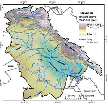
Figure 9: Tigris and Euphrates River catchment area (Flint et al. 2001)

Figure 10: Tigris and Euphrates River Basin (Flint et al. 2001)
Climate Change Experienced on the Regional Scale
In all climatic changes and their consequences, those expected in the South Eastern Anatolia Region, which forms the southern part of Turkey and north east of Iran cannot be overlooked in any study on the impacts on the Euphrates and Tigris Rivers water resources.
It is logical to expect that water resources, both, surface water and groundwater in the Middle East and East Mediterranean EMME will be negatively affected as a direct consequence of the precipitation reduction and increased demand due to higher evapotranspiration and the growth of population Studies of changes occurring over this region have revealed that these changes can be traced to and have resulted from the changes imposed on the North Atlantic Oscillation (NAO) which in turn falls under the impact of Global Climate Change and results from it. The North Atlantic Oscillation (NAO) is a weather phenomenon in the North Atlantic Ocean; of fluctuations in the difference of the atmospheric pressure at sea level (SLP) between the Icelandic Low and the Azores High. Through these fluctuations it controls the strength and direction of westerly winds and location of storm tracks across the North Atlantic and surrounding regions. It is part of the Arctic oscillation and varies over time with no particular periodicity. The (NAO) was discovered and investigated through several studies in the late 19th and early 20th centuries (Hurell, 2001). Unlike the El Niño-Southern Oscillation phenomenon in the Pacific Ocean, the NAO is a largely atmospheric mode. It is one of the most important manifestations of climate fluctuations in the North Atlantic and surrounding humid climates. Modifications to these oscillations due to Global Climate Change naturally results in changing weather patterns over the regions where this mode prevails; including the East Mediterranean and the Middle East region (EMME) of which the Euphrates and Tigris Basin is one part, Figure (11)
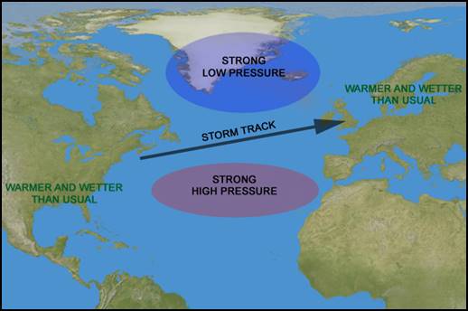
Figure 11: NAO and how it affects Southern Europe, Middle East and The Mediterranean weather
The Euphrates and Tigris Basins forms a major part of the Eastern Mediterranean and the Middle East region (EMME), and consequently this basin is subject to weather modifications as foreseen by the Intergovernmental Panel on Climate Change (IPCC) models. These models indicate that storms activity in the eastern Mediterranean is part of the NAO pattern and it will decline this century if global warming continues on the present trends. Therefore, rainfall will decrease by 15 to 25% over a large part of the land; encompassing parts of Turkey, Syria, northern Iraq and north-eastern Iran; including the strategically important headwaters of the Euphrates and Tigris rivers. Although the Euphrates and Tigris Basins occupy large part of southern Turkey, north and northeast of Syria, north and northeast of Iraq and, northwestern part of Iran, these parts do not contribute proportionate shares in the water resources of the basin, so while this basin falls generally under the influence and impacts of Global Climate Change in the Middle East and North Africa (MENA), these impacts are modified to varying degrees by changes occurring to the NAO over these parts. This is a result of the large geographical extent of the basins, and due to changes in topography within it, which includes mountain ranges, inland lakes, and even deserts (Hemming et al., 2010) Recent work done by the University of New South Wales Climate Change Research Centre (Evans, 2009) suggests that the Climate Change projections on this region presents a significant challenge to the region’s agricultural base, with longer dry seasons and changes in the timing of maximum precipitation .
The study; however, notes that projections based solely on the results of the global climate change modeling tend to obscure smaller-scale regional effects. Therefore, by using the regional climate modeling specific to the Middle East, the results obtained by the same researcher suggest that despite declines in the storm activity the moisture-bearing winds could be channeled inland more often and diverted by the Zagros Mountains bringing an increase of over 50 % in annual rainfall to some very limited localities in the Euphrates and Tigris basins and by that emphasizing on the modifications resulting from changing topography. These widely ranging projections and interpretations of different sources depict an uncertain future for the basin’s climatic conditions and indicate the need for further modeling studies to reach more definitive conclusions. It may be said; however, that the use of currently measured conditions and trends serve to lay a foundation for forecasting future changes in climate and hydrology, but it also requires at the same time to develop new models more adapted to the natural conditions of this region. Cullen et al. (2000) employed standard statistical techniques to analyze data available from the National Climate Data Center (NCDC), Global Climatic Perspective System (GCP), and stream flow records obtained from Turkey through the UNESCO for the period 1938-1972. The end of this record marks the initiation of the implementation of the Greater Anatolia Project (GAP) when the publication of Turkish hydrological data was stopped by the authorities. The other used data included a short record (1965-1972) of the Tigris River stream flow in Baghdad. The results of this study confirmed that the stream flow of the Tigris and Euphrates Rivers are associated with the North Atlantic Oscillation (NAO), which governs the path of the Atlantic mid-latitude storm track and precipitation in the Eastern Mediterranean. As the sea level pressure over the North Atlantic oscillates seasonally; A Sea Level Pursuer Index (NAOSLP) can be calculated as a simple difference between the normalized mean-variance at different locations, and it is used to indicate the signature of the NAO in these locations. This index was defined and developed by Walker et al. (1932) and Rogers (1984). Results of Cullen et al. (2000) study showed that the Euphrates and Tigris flow integrate regional precipitation variations over the headwater region in Turkey in the months from December to April (DFMA), which is clearly subjected to (NAOSLP) as shown in Figures (12 and 13). In Figure (12), a strong relationship was indicated between the monthly stream flows of the Euphrates River measured in Keban (35 year mean values) and the monthly averages for the three lowest NAO years (1940, 1963, 1969) , and monthly averages of the three highest years (1945, 1949, 1961). Similar relationship would also apply for the Tigris River due to the similar conditions. In Figure (13 a), a strong correlation is observed between the (NAOSLP) and the Turkish winter temperature index, the Turkish winter precipitation index, and the Euphrates average stream flow for the winter months (DJFMA) over the years of record (1930-2000) are shown in Figures (13 b) and ( 13 c) . Again similar correlation would appear for the Tigris River flow. These results support the proposition that; among other factors the variations of NAO as a result of Global Climate Change has its bearing on the climate changes expected in the Euphrates and Tigris Basins, and; therefore, future studies on the impact of global warming on the two river basins must not neglect the NAO variation’s effects. Other things to be considered are the exact geographical locations within the basin of the area to be studied and the topographical features should be considered.

Figure 12: Monthly flow of the Euphrates River stream (solid line) measured at Keban, Turkey (35-year mean). Monthly averages for the three lowest NAO years (1940, 1963 and 1969; dashed line with filled circles, 2s S.D. shown), and monthly averages of the highest years (1945, 1949 and 1961; dashed line with triangles, 2s S.D. shown)
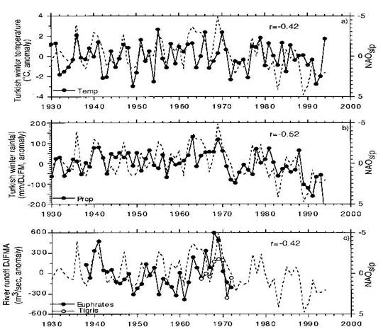
Figure 13: Correlation between the NAOSLP index, (a) Turkish winter temperature index, (b) Turkish winter precipitation index and (c) DJFMA average stream flow of the Euphrates (filled circles) and the Tigris Rivers (open circles) (note: the NAOSLP index has been multiplied by _1
Modeling studies of Climate Change Impacts on the Euphrates and Tigris Basins
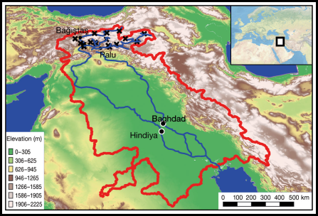
Further modeling studies have been performed so far to determine the impacts of Climate Change on future water availability in the Tigris-Euphrates Rivers’ Basins. According to a recent study (Voss et al. 2013), the Tigris-Euphrates Rivers’ Basins experienced substantial water loss between January 2003 and December 2009, based on measurements of NASA’s Gravity and Climate Experiment (GRSA’s) Satellites. Chenoweth et al. (2011) investigated the likely future effects of the Climate Change on the water resources of the Eastern Mediterranean and Middle East regions using a high resolution climate model forced by lateral boundary conditions from the HadCM3 (abbreviation for a Hadley Model- version 3), which is coupled to atmosphere-ocean general circulation model (AOGCM) which is developed at the Hadley Centre in the United Kingdom and was one of the major models studied and formulated in the IPCC- The Scientist Basis (IPCC, g. 2001). In this study, this model was driven by the (A1B) scenario formulated in the IPCC special report on emission scenarios SERES (IPCC, h.2000); and it was found that the average annual Euphrates- Tigris Rivers’ discharges may decline by 9.5% between 2040 and 2069, with the greatest decline (12%) in Turkey and only (4%) in Iraq. They also projected further decrease in the two rivers in the period 2070-2099; however, the decrease would be < 1%. To simulate the Climate Change Impact over the Euphrates and Tigris basins in terms of the decrease of discharges of the two rivers as compared to a known reference base period in which these discharges were recorded, Bozkuri et al. (2015) applied both the hydrological model (HD) of the Max Plank Institute which was developed by Hagemann et al. (1997 a) and Hagemann et al. (2001 b) to simulate discharge from the outputs of two chosen General Circulation Models GCMs ( AIB) scenarios, and Regional Climate models for climate application (RCMs); which was pioneered by Dickinson et al. (1989). For the reference base period ( 1961- 1990) meteorological data from the upper Tigris-Euphrates Rivers’ Basins in Turkey were obtained from the Turkish Meteorological Service and discharge measurements records were obtained from Palu and Baağiştas discharge measuring stations in Turkey, and Baghdad and Hindiya discharge measuring station in Iraq as shown in Figure (14 ).
Figure 14: Catchment area of Tigris and Euphrates, Discharge measuring stations marked (•), Weather Stations marked (x)
In terms of the reference period (1961- 1990), simulations of 30-year daily surface runoff from the GCMs models and from the dynamically downscaled outputs of the same period were used to drive and calibrate the HD model. The outputs of the used models are indicated in Figure (15). This Figure shows the mean annual discharge cycle for Palu, Baağiştas, Hindiya, and Bagdad gauging stations forced, by General Circulation Model’s outputs and RCM outputs for the base period (1961-1990). Figure (16) gives the mean annual discharge cycle of the reference period (1961-1990) and the future period (2071-2100) at the Palu, Baağiştas, and Hindiya gauging stations from the various simulations. The discharge is projected to increase slightly between November and December as a result of more pronounced temperature increase at the end of the century resulting in earlier melting of snow, and the slight increase in January is related primarily to snowmelt runoff; but, the discharge in general is expected to decrease during the rest of the year. Further river discharge simulations indicate a striking decrease in the mean annual discharge for the Euphrates River by the end of the current century, ranging from 19% to 58%, according to the various models used. These results, even with a certain margin of uncertainty resulting from the uncertainties embedded in the GCMs models mean that any future planning within this basin must be treated with caution and prudence.
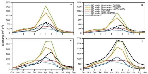
Figure 15: Mean monthly discharge for (a) Palu, (b) Baağiştas¸ , (c) Hindiya and (d) Baghdad stream flow gauging station (black continuous line) and the HD model simulation results (dashed lines) forced by GCM-ECHAM5 (blue), MPI-ESM (red RCM-NCEP/NCAR (orange), RCM-ECHAM5 (green) and RCM-CCSM3 (dark blue). Note differences in y-axis scales (1961-1990)
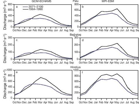
Figure16: Mean monthly discharge (m3/ s) simulated by the HD model for (a, b) Palu,(C,d) Baağişas¸ and (e, f) Hindiya for the reference (black solid line) and future (blue dashed line) periods. Forcing- (a, c, e) GCM-ECHAM5; (b, d, f) MPI-ESM. (Base period 1969-1990, Future period 2071-2100)
What does Climate Change mean for Iraq?
The geographical location of Iraq puts it at the center of the East Mediterranean Region. Bound by South Anatolia in the north, northwestern Iran in the east, Syria and Jordan in the west; it opens on the Arabian Desert and the Persian Gulf at the south. Center of l Iraq may be located on the coordinates (33.2232° N) and (43.6793°E), Figure (17). This position added to its varied topography brings with it many changing weather elements which are showing various degrees of variations due to the current Global Climate Change.
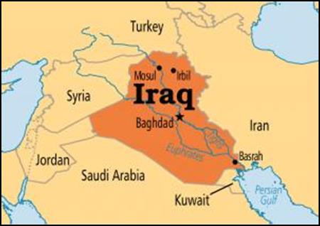
Figure 17: Iraq’s Map indicating the neighboring countries
Countries and communities around the world are already experiencing stepped-up climate change impacts; including rising temperatures, droughts, floods, shortages, more intense and frequent natural disasters, and sea level rise. The countries most vulnerable to climate change are being hit the hardest. Iraq is being one of these countries, which has been struggling with significant and interconnected environmental, security, political, and economic challenges; with the effects of climate change likely increasing the extent of these challenges. Rising temperatures, intense droughts, declining precipitation, desertification, salinizations, and the increasing prevalence of dust storms have undermined Iraq’s agricultural sector. Additionally, Iraq’s water security is based on two declining rivers, the Tigris and Euphrates. National and regional political uncertainty will make mitigating the effects of climate change and addressing transnational water management very difficult. Climatic changes such as increasing temperatures, reduced precipitation, and increasing water scarcity will likely have serious implications on the state of Iraq for years to come USAID (2017). These changes and their manifestations and consequences are discussed in more details in the following:
Water Scarcity
Climate change due to global warming has influenced all the weather driving elements not only in Iraq but in all the surrounding countries. These changes include temperature rise, atmospheric pressure variations, rainfall intensities and its temporal and spatial distribution; which have contributed also to changes in annual stream flow volumes of the Tigris and Euphrates Rivers. Model studies have shown that these negative trends will continue at least to the end of this century and may be accentuated as long as the green house gases (GHG) emission which include CO2 continue at the present rates. These models indicate that storms activity in the Eastern Mediterranean Region is part of the North Atlantic oscillation (NAO) pattern and it will decline this century if global warming continues. Therefore, rainfall will decrease by 15 to 25% over a large part of this region; encompassing parts of Turkey, Syria, northern Iraq and north-eastern Iran and including the strategically important headwaters of the Euphrates and Tigris rivers. Adamo et. al. a (2018). Other studies have indicated declining precipitation over all the Tigris River tributaries basins in Iraq with alarming results. These Studies also indicated that precipitation had already shown a general decline in the decades 1980- 1990, 1990- 2000 and 2000- 2010 with a decreasing spatial trend from upstream to downstream and from east to west of the basin; this is attributed to the fact that the northern and northeastern parts of the basin are mountainous with high precipitation and snowfall, while the lower and west parts are relatively flat with less precipitation. Future projections showed that under the optimistic emission scenario (B1) the mean annual precipitation over Khabour River basin will decrease by 7% during the future period 2046- 2064 and 15% during the period 2080-2100.but the reductions are estimated to be 18% and 38% respectively under the pessimistic emission scenario (A2) during the same two periods. The Diyala River basin will undergo precipitation reduction of 17% in the two future periods under (B1) scenario and 26% and 40% under scenario (A2) in the two periods. Greater Zab, Lesser Zab and Al Adhaim River basins will undergo similar reductions under the same scenarios and in the same future periods, Adamo et. al. b (2018). At the present, climate change is having its toll also on the Tigris and Euphrates rivers stream flows. The fact that these rivers originate out of Iraq’s borders and that their watersheds fall in areas which are subject to the same climate change influences reflects on their declining natural stream flow. The situation is aggravated in recent decades and even now by the increasing water withdrawals in the other riparian countries due to their increasing demand, namely Turkey and Iran, and to a lesser degree Syria. Figure (18)1 the gives riparian countries shares in the water supply of the two rives according to the Iraqi Ministry of Water Resources. Future projections and assessments of the regional water resources under Climate Change future impacts and with Tigris and Euphrates at focus have shown that the situation is far from being bright. Chenoweth et al. (2011) investigated those likely effects on the water resources of the Eastern Mediterranean and Middle East and it was found that the average annual Euphrates- Tigris Rivers’ discharges may decline by 9.5% between 2040 and 2069, with the greatest decline of (12%). Another study predicted that the Euphrates River annual flow could suffer a reduction of (29 – 73) %, (Kitoh et al., 2008 Further strain is put on these resources by the continued pollution and salinization of the two rivers due to increasing use of fertilizers and discharge of industry effluence and domestic waste and sewerage without enough treatment. Water is becoming with the passage of time more and more a scarce commodity in the whole region and especially in Iraq with Climate Change unhampered impacts and continuous human misuse.
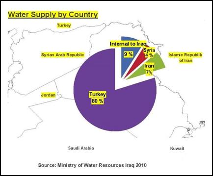
Figure18: Water Supply by country to Tigris and Euphrates water resources, after the Ministry of Water Resources-Iraq (2010)
Desertification, Drought, and Sand Storms
Decreasing rainfall is one of the significant factors that simultaneously marks and intensifies desertification. Climate Change exacerbates desertification through changing of spatial and temporal patterns of rainfall. The variation of rainfall amounts causes changes in the land vegetative cover through both numbers of dry years or seasons resulting in very long drought periods. The increase in the temperatures as a result of the Climate Change causes the changing of the soil properties and processes, such as organic matter decomposition, greater leaching losses, decreased soil water, and degradation through reducing soil moisture, and soil erosion in some regions because of heavy rainfall and increased wind speed IPCC, f 2007) Climate Change also accelerate desertification through changing the regional water resources systems regime by disrupting the balance between water outflow and inflow due to the variation of rainfall amounts and increasing temperature, which enhances evaporation and evapotranspiration. The fact that Climate Change Impact are causing droughts and increased desertification is becoming quite evident in recent years in Iraq and Syria forming the two limbs of what is known as the “Fertile Crescent” Figure (19). One study employed a super-high-resolution atmospheric global climate model to reproduce the precipitation and the stream-flow of the present day “Fertile Crescent” and projected the current trends in climate changes on the Middle East water resources till the end of the century. The results showed severe reductions of the annual discharges of the rivers in the region. The Euphrates River annual flow; as one case might suffer a reduction of, (29 – 73) %, as well as the stream flow of the Jordan River (Kitoh et al., 2008) In the wider picture of the Middle East, the study showed that, by the end of this century, the “Fertile Crescent” would lose its current shape and could disappear altogether.
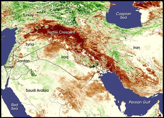
Figure19: The so-called “Fertile Crescent” in a NASA image
The area shown in Figure (19) witnessed one of the most devastating droughts in decades in (2007-2008); which scientists have linked to Climate Change. This severe drought hit most of Syria and northern Iraq during what is normally the wettest time of the year. In the mountains of eastern Turkey, which form the headwaters of the Tigris and Euphrates rivers, snow and rain were less than half of the normal. Drought is becoming a fixture in this landscape, due to a drying trend of the Mediterranean and Middle East Region which is fueled by global warming (Holthaus, 2014). The current and future impacts of Climate Change inevitably will lead to decreasing lake sizes, drying wetlands and changing the regional environment (Sivakumar, 2007). This trend will impede and hamper the current efforts to restore the marshes of southern Iraq and may result in their drying up. Given the impact of low rainfall and wasteful irrigation practices in Iraq, environmentalists predict the marshes will remain at a fraction of their typical size (Schwartzstien, 2015); if not disappear altogether. A 2009 report by UNDP described the impacts of the global warming on Iraq and it underscored the severe droughts it had experienced and the declining precipitation over the Tigris and Euphrates basins in the 5-10 years previous to the report, which amounted only to 25-65 percent of normal levels. This study shows that Climate Chang Impact is the main reason expressed in the form of global warming and changes in the North Atlantic Oscillation (NAO) (UNDP, 2009). The same study goes on to explain that these changes will increase the likelihood of massive dust storms as a result of losing soil moisture and vegetation cover, and furthermore, the impacts are expected to be more severe as time passes and will lead to more destruction of physical and chemical characteristic of the soil in Iraq’s arable and non-arable lands. Taking all the predictions of the future Climate Change Impact on the Tigris and Euphrates river basins, the productive land, especially in Iraq will be reduced to a barren land with extensive deserts, and only narrow strips of irrigated stretches along the two rivers will remain . A direct consequence of the increased aridity, which is strongly felt, is the occurrence of sandstorms. A study of sand and dust storms events in Iraq by (Sissakian et al. 2013) indicated that the frequency of occurrence of dust storms has increased drastically during the last decade and it is increasing continuously. According to United Nations report, it indicates that the Iraqi Ministry of Environment has recorded 122 dust storms and 283 dusty days in 2012 and it estimates that this will increase to 300 dusty days per year in the next ten years. (UN. 2013). A typical image of such an event is shown in Figure (20).
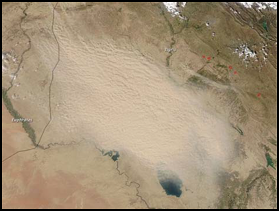
Figure (20): Aerial view of a dust storm. Note it had started just in the northwestern borders of Iraq (The Moderate Resolution Imaging Spectroradiometer (MODIS) on NASA’s Aqua satellite captured this natural-color image on March 3, 2011).
The recent changes on the different climatic factors in the Middle East are mostly attributed to the Global Climate Change Impact. The area has experienced enormous changes in the average annual temperatures and the average annual precipitation contributing to increased desertification followed by increased sand and dust storms events. A large part of Iraqi has changed into a (Very High Potential Zone) for the occurrence of such storms as a direct consequence, and only a small area in the extreme northeastern part shows (Moderate Potential) for dust storms. A global dust potential map published by the Desert Research Institute (DRI 2013) is shown in Figure (21) which shows clearly this fact. Taking the current trends of the future Climate Change Impact on the Tigris and Euphrates river basins which have just been explained; the phenomenon of increased sand and dust storms will reach unimaginable limits and worsen life quality and bring it to very low levels by the end of the century unless some corrective measures are taken on the regional and local scales. Such measures may include stabilization of sand dunes, creating wide and extensive green zones around cities, large scale afforestation using trees and shrubs with high tolerance to moisture deficiency, and by applying modern practices in conserving water and soil resources. It also requires the cooperation of neighboring countries in performing similar actions.
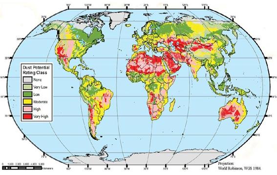
Figure (21): Global Dust Potential Map
Sea Level Rise (SLR)
Sea level rise (SLR) is another obvious impact caused by climate change which is leaving its mark on many countries in the world which have coastal areas. It is very likely that the 20th-century global warming has caused an increase in the size of seas and oceans as well as loss of land ice (IPCC.2001, b, d). During the period 1961-1993 there was an observed global sea level rise of about 1, 8 mm/year as an average, while during the period 1993-2003 this rate was 3.1 mm/year. This had increased to 3.6 mm per year between 1993- 2010 was and it is still rising (IPCC.2007e The Middle East and North Africa Region (MENA) countries are vulnerable to the impacts of SLR as most of the other countries of the world with coast lines. But despite the fact that their coastlines are subjected to these impacts, this will be more noticeable in countries that have deltaic areas, such as Egypt (Nile River delta) and Iraq (Tigris and Euphrates delta) as clearly indicated in Figure (22). These two areas are the most vulnerable within the (MENA) countries by sea level rise, according to Ghoneim (Ghoneim, 2009).

Figure 22: The Situation of the sea level rise for Egypt (Nile River delta and Iraq (Tigris and Euphrates delta (Shown in red and yellow colors (Ghoneim, 2009)
Climate Change Computer Modeling also projects sea level rising by over 0.5 meters by the end of the century. One report indicates that this will place low-lying coastal areas in the Gulf and Shatt-al-Arab area, and North Africa at particular risk with specific mention of Iraq (World Bank.2013).
One survey which was done on the implications of the global warming on coastal zones of the Arab Region highlighted the vulnerability of the Arab countries to potential impacts of sea level rise. (El Raey, 2010). The study indicated that most of these countries, if not all of them, are extremely vulnerable to the impacts of the sea level rise; not only through direct inundation but also due to salt water intrusion. Another study looked into the impacts of SLR on the Arabian coastline and highlighted those countries with high potential risk of SLR (Ghoneim, 2009). It indicated that a simulation of SLR has been conducted using the Geographical Information System (GIS) and the Shuttle Radar Topography Mission (SRTM) data. Under the (1 m) SLR scenario, the simulation reveals that approximately 41,500 km2 of the territory of the Arab countries would be directly influenced by the rise of the sea level. But taking into account the full “likely” range of the predicted increases in temperature, SLR could even be amplified up to (1.4 m) by the year 2100.
In dealing with the of Shatt al-Arab estuary at the head of the Arabian Gulf, the shoreline of Iraq is very limited; however, it is considered one of the most threatened areas in the region because of its low elevation with respect to the sea level. The low elevation areas appear to extend through Basra City and to the north of it even for the (1m) sea level rise. The potential impact may affect soil salinity by salt water intrusion and may cause serious inundation of many parts of the Tigris and Euphrates delta and drive the population out and cause loss of the infrastructures. For a (3 m) sea rise, the intrusion of the sea can reach Amarah and beyond Nasiriyah city. Figure (23) shows the extent of inundation that could be caused by sea level rise in Iraq as depicted by the scenario of sea level rise of (+1m), and Figure (24) shows this extent for the scenario of sea level rise of (+3m).
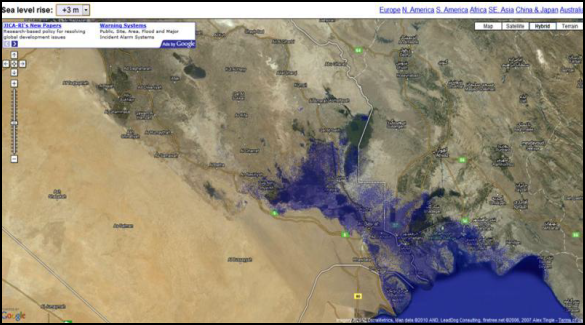
Figure 23: Extension of sea level rise in Iraq as represented by the scenario 02of sea level rise of (+1m)
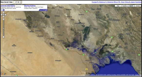
Figure 24: Extension of Sea Level Rise in Iraq as represented by the scenario of sea level rise of (+3m)
On the coast line, Umm Qasr and Al- Faw the two Iraqi ports are shown in Figure (25). They are the only Iraqi sea ports which support trade, shipments, and various businesses and industries including oil exporting and storage. But, they both are vulnerable to sea level rise and changing weather patterns that may increase erosive action on the natural features of the coast, as well as infrastructures.

Figure 25: The coast line between Um Qasr and Al Faw
This area is very low-lying and susceptible to any amount of sea level rise, as well as being subjected to redistribution of coastal and marine sediments during extreme storm events, which clogs shipping channels and forces frequent dredging. The sea level rise, and constant movement of the lowest low-water mark, which defines the maritime borders with Kuwait and Iran has the potential to create international conflict with regard to the location of shipping corridors; there have already been several incidents related to this in recent years between Iran and Iraq. In addition, Shatt al-Arab is already suffering from salt water intrusion mostly related to lack of freshwater discharge and sea level rise will exacerbate this problem.
Almost all the possible impacts of climate variability in Iraq are currently being felt in the Marshlands and adjacent areas in the south, due to the fact that this area is a receptacle for all river discharge and irrigation drainage in Iraq and is also exposed to the influences of sea level rise which results in increasing salinity in the southern fringes, through the Shatt al-Arab and into portions of the Hammar Marsh. Thus, it is a globally significant area (wetlands with high biodiversity and traditional cultures) that is being assaulted on two fronts (from the north and from the south) (El Raey, 2010).
Socio-economical impacts due to climate change
Climate change in general acts as a threat multiplier, exacerbating existing sociopolitical and economic vulnerabilities, undermining livelihoods, inflating the risk of conflict and making it difficult for people to remain in situ. Socio-economic conditions in the world as a whole, and taking Iraq an example, are influenced by the impacts of the rapid climate changes on its natural resources. Such impacts include the increase in frequency and severity of extreme weather events and other manifestations such as sea levels rise; All, if they are left unmanaged or controlled will increase stresses on the critical resources and infrastructures that support water and food security, transport and energy systems, and impinge directly on life quality as a whole. These climate change threats coupled with other negative factors my highlight the dangers to social security and undermine the ability of governments to manage volatile situations; leading to what can be described as a failing state. In a recent report entitled “Epicenters of Climate Change and Security: The New Geostrategic Landscapes and the Anthropocene” (Werrell et. al. 2017) the authors emphasize that climate change impacts contribute to a broad range of destabilizing trends within states, including population displacement, migration, political unrest, state fragility, internal conflicts, and they imply also that the transboundary nature of some climate change impacts may lead to conflicts between states. In the last case the Tigris and Euphrates River flows may be cited as an example; the decrease of water resources due to natural climate change impacts coupled with the unfair sharing of water by Turkey and Iran may lead to armed conflicts between these two countries and one or two of the other riparian countries namely Iraq and Syria. Such action may be taken in desperation and under popular pressures and unrest In looking into the socio-economic developments in Iraq it is very clear that the climate change impacts are negatively affecting the country with much more severe negative changes expected in the future. Agriculture in Iraq for one thing has been declining in recent years for variety of reasons with climate change as being one of the major negative actors. Agricultural output and cultivated farm land area have been showing negative trends which are clearly indicated by the escalated migration from the country side to urban centers and the soaring imports of food and agricultural products. One study which was done by Cline (2007) treated the global warming effects on agriculture and listed these impacts for most of the countries of the world including Iraq. Agricultural impact models of two types, “Ricardian” statistical economic models were used with process-based agronomic crop models, combined with leading climate model projections. A set of geographically detailed estimates for changes in temperature and precipitation by the 2080s were developed and applied to the chosen agricultural impact model; i.e. The Agriculture Mendelson- Schlesinger Model. These estimates were obtained and used for 116 countries, regions and subzones taking their 1961-1990 climatic values as base period then comparing the changes in the predicted agricultural outputs values against the actual outputs values in 2003 which then were compared to those values in 2007 and then projected to the future period 2070- 2099. In this report Iraq was indicated as one of the most badly hit countries of the world together with 30 more countries. The detailed results given for Iraq showed that according to changes in temperature and precipitation and agricultural output values averages of the base period 1961-1990 taken together with the actual agriculture output value of 370 million dollar in 2003 ; this output value declined to an amount of 266 million dollars in 2007, the projected values for the future period 2070-2099 will decline even further 728 million dollars (without Carbon fertilization) or 685 million dollar (with carbon fertilization) depicting a decline of more than 100 percent from base period in 1961- 1990. Such decline can only be described as catastrophic and it will have deep and extensive negative out comes on the state of Iraq. The migration from rural areas to urban centers due to the shrinkage of cultivated land area and the declining output will be exasperated and adds further difficulties to the local authorities and strain their capacities to meet population demands for services such as sanitation, potable water supply, clean environment and basic health services; such services are already inadequate now due to variety of reasons which includes among other things incompetent management and lack of resources. Competing over irrigation water between different users has strained social relationships and caused the eruption of armed skirmishes between various clans in southern Iraq which even required the intervention of security forces to calm down such situations. These can only be seen as warning signs of the worst to come if these trends continue at the expected rates.
Discussion and Conclusions
Climate Change Impact is evident on global scale. It is basically driven by global warming which is resulting from the ever increasing and unwise use of fossil fuel as energy source. Scientific evidence attributes this rise in temperature to increased release of carbon dioxide CO2 due to the increased use of fossil fuel together with other gases known as the Green House Gases (GHG). According to the Intergovernmental Panel on Climate Change (IPCC) this global warming cannot be separated from the disruptions it had caused to the weather patterns all over the world which include higher temperatures, erratic precipitation modes and circulation patterns. This is causing more flooding in some areas compared to decrease in rain and droughts in others. These erratic phenomena are experienced in the East Mediterranean and Middle East Region which encompasses the Euphrates and Tigris basins, the two main rivers of Iraq. The present measured and projected trends in this region show increasing temperatures with decreasing precipitation over the two rivers catchment areas in South Eastern Anatolia, Northwestern and Eastern Iran and North of Iraq. Much research work has been done so far in trying to define the magnitude of the changes to be anticipated in this most sensitive part of the world but technical modeling studies have concentrated on the purely technical aspects leaving their outcomes to be assessed and handled by politicians. It may be said; however, that the use of currently measured conditions and trends serve to lay a foundation for forecasting future changes in climate and hydrology, but it also requires at the same time to develop new models more adapted to the natural conditions of this region. The present studies show a drastic decline of the Euphrates and Tigris water resources at the end of this century by something like 30% to 70% as compared to their resources in the last three decades of the previous century. While we do not want to dispute these wide variations in the projections we do emphasize that the future is dark as far as those two rivers are concerned, and that these studies should bring alarm to all responsible governments in the region to resort to long range planning by adopting rational policies in soils and water resources management to mitigate the adverse impacts that could hit human societies in these events. This may also bring the Wise Men in the region to come together to have mutual cooperation on this most important subject. The particular case of Iraq indicates that its role to combat the increasing Co2 emission on the world scale is limited. Although the country has already signed the Paris Agreement on climate change in December 2015, pledging to reduce greenhouse gas emissions by 15% between 2020 and 2035, the equivalent of 90 million tons of carbon dioxide, but Iraq does not have such a large number of industrial facilities or power plants or even so much use of fossil fuel, as is the case in industrialized countries, and the rates of fuel combustion in Iraq are much less than those of said countries. It follows that corrective and protective actions should be taken immediately within Iraq itself to limit and reduce future negative consequences. The only meaningful action taken so far in the context of environmental changes was the launching of the National Action Program to Combat Desertification in 2015.by the Ministry of Health and Environment with support from the United Nations Environmental Program (UNEP) and some other regional organizations. Although this only addresses one of the many consequences of climate change, it is believed that the recommended actions in this program have not been t fulfilled so far due to variety of reasons; of which; lack of financial resources and instability in some parts of Iraq are to be mentioned. In view of the colossal problems facing Iraq, however, there is the need to develop a comprehensive and continuous plan to limit the expected consequences of Global Change Impacts and to put it into application immediately. One of the elements of this plan is to introduce radical changes to all the water and soil management policies and practices. The water sector in Iraq at the moment is suffering from endemic problems. The wide spectrum of these problems includes among other things the wasteful use of water, use of old and traditional irrigation practices, deteriorating irrigation infrastructures, illiteracy of farmers and their lack of modern technical skills, weak administrative frameworks in addition to the lack of meaningful legislations to control water use. In this field the government has a challenging task to revolutionize this sector even if this is done on stages of five or ten years. Water scarcity in Irrigated lands requires saving every drop of water and put it to the best use. This needs sorting out the better quality lands for cultivation and crop production while the other lower quality and marginal lands should be set aside for afforestation and foliage , converting all the existing irrigation project to the use of modern methods by changing to closed irrigation systems, drip irrigation and sprinklers especially in the north of the country where this can be used as a complementary measure, rehabilitation of all the irrigation structure and use of automation, strengthen the administrative and management frameworks with better monitoring and control of water sharing and supported by effective legislations and strong authority for their implementation. Better and fair pricing of water is strongly recommended to stop the current waste of this limited resource not only in the agricultural sector but in the domestic and sanitation sectors also. Use of recycled water and desalinization of salty water should be considered seriously to help in the abatement and mitigation of future increased shortage. While all these actions shall be planed and implemented the governments eyes must at the same time fixe on getting a fairer and better sharing of water with the riparian countries of the Tigris and Euphrates; namely Turkey and Iran, which can be done through continuous negotiations based on exchanging of benefits. In combating the sea level rise impacts on the southern delta and sea coast line it is necessary to carry out much more studies to define in a more accurate way and refined details the exact changes and their locations. Based on these studies plans can be prepared for staged implementing of protective works in the form of dikes and sea shore revetments. Settlements in areas that cannot be protected shall be replaced by new ones somewhere else and no permanent works are allowed on them while settled population has to be moved to other safe areas after providing all good living conditions there. As a conclusion it may be said that Iraq is facing existential problems resulting from Climate Change Impacts over the few coming years. These impacts are manifested by the gradual changes to all weather driving elements at work now, and which will be severely threatening its population in the future and disrupt social peace. Actions to mitigate these problems must be started now or, otherwise such problems may even cause the disintegration of Iraq as a state.
References
National Research Council, The Committee on grand research questions in the solid-earth sciences. “Origin and Evolution of Earth: Research Questions for a Changing planet”. National Academies Press, Washington, D.C., 2008..(paperback). ISBN 978-0-309-11717-3. https://www.nap.edu/catalog/12161/origin-and-evolution-of-earth-research-questions-for-a-changing Muller, R A. “Physics and Technology for Future Presidents; Chapter 10”. Princeton University Press. 2010. http://muller.lbl.gov/teaching/Physics10/PffP_textbook/PffP-10-climate.pdf Muller R .A . Jacobson B. “Physics and Technology for Future Presidents” Downloaded from selected Textbook Chapters. Chapter 10 (climate) of the old version (2007)”. Web page: http://muller.lbl.gov/teaching/Physics10/PffP.html IPCC. a. “Assessments Reports (1990- 2013)”. https://www.ipcc.ch/publications_and_data/publications_and_data_reports.shtml WMO. “Frequently Asked Questions; what is Climate Change. 1979 http://www.wmo.int/pages/prog/wcp/ccl/faqs.php#q4 IPCC. b.“Climate Change: The IPCC Scientific Assessment, Introduction (1990). https://www.ipcc.ch/publications_and_data/publications_ipcc_first_assessment_1990_wg1.shtml IPCC. c Working Group 1. “Climate Change: Understanding and attributing climate Change, The Physical Science Basis.”. Fourth Assessment Report,2007. http://www.ipcc.ch/publications_and_data/ar4/wg1/en/spmsspm-understanding-and.html IPCC d. Working Group III “Special Report on Emission Scenarios-SRES.”. IPCC-UNEP https://www.ipcc.ch/pdf/special-reports/spm/sres-en.pdf Zakaria S. Al-Ansari N, Knutsson. 2013. “Historical and Future Changes Scenarios for Temperature and Rainfall for Iraq”. Journal of Civil Engineering and Architecture, Volume 73. No, 12. PP.1574-1594. Dec. 2013). https://www.diva-portal.org/smash/get/diva2:988358/FULLTEXT01.pdf WRI .Earth Trends Data Tables: Climate and Atmosphere. World Resources Institute. Washington D.C. 2005. http://pdf.wri.org/wrr05_dt_all.pdf Trondalen, Jon M. “Climate changes- water Security and possible remedies for the Middle East”. U.N., World Water Assessment Program, UNESCO.20.2009. http://unesdoc.unesco.org/images/0018/001818/181886e.pdf IPCC .e. Climate Change: Assessment Report . “Sea level Change”.201 https://www.ipcc.ch/pdf/assessment-report/ar5/wg1/WG1AR5_Chapter13_FINAL.pdf IPCC. f. Climate Change: Synthesis Report. “The Physical Science Basis”. Synthesis Report. 2007. https://www.ipcc.ch/publications_and_data/publications_ipcc_fourth_assessment_report_wg1_report_the_physical_science_basis.htm Ghoneim E. “A Remote Sensing Study of Some Impacts of Global Warming”. Chapter 3.Arab Environment Climate change- impacts of climate change on Arab countries. Edited by Tolba M and Saab N, 2009 http://www.afedonline.org/afedreport09/english/char3.pdf Lelieveld J, Hadjinicolaou, P., Kostopoulou. “Climate change and impacts in the Eastern Mediterranean and the Middle East”. Springer, 2012, https://link.springer.com/article/10.1007/s10584-012-0418-4 Kitoh A, Yatagal A, Alpert P. “First Super-high- Resolution Model Projection that the ancient will disappear in this century”. Hydrological Research Letters, 2.14.The Japan Society of Hydrology and water Resources. 2008. http://www.hrljournal.org/archives/67#more-67 Mark J.J. “Fertile Cresent”.Ancient History Encyclopedia”. 2009. https://www.ancient.eu/Fertile_Crescent/ Weiß, M., Flörke, M., Menzel, L. and Alcamo, J. 2007. Model – Based Scenarios of Mediterranean droughts. Advances in Geosciences. Vol.12, Katlenburg-Lindau, Germany, Copernicus Publications, pp. 145-51. http://www.adv-geosci.net/12/145/2007/adgeo-12-145-2007.pdf Flint A, Flint L, Curtis J, Boesch C. “A Preliminary Water Balance Model for the Tigris and Euphrates River System” USGS.2 https://ca.water.usgs.gov/projects/reg_hydro/projects/Flint_water-balance-model-tigris-euphrates_2011.pdf Hurell J. “The North Atlantic Oscillation: Climatic Significance and Environmental Impacts”. National Center for Atmospheric Research, 2001 http://www.iii.org/sites/default/files/docs/pdf/Hurrell.pdf Hemming D, Buontempo C, Burke E, Collins M, and Kaye N. “How uncertain are climate model projections of water availability indicators across the Middle East?” Philosophical Transactions, the Royal Society. Oct 2010. http://rsta.royalsocietypublishing.org/content/368/1931/5117 Evans P. “21st-century climate change in the Middle East”. Springer Link. Vol. 92, Issue 3-4 Feb.2009. https://link.springer.com/article/10.1007/s10584-008-9438-5 Cullen H, deMenocal. “North Atlantic influence on Tigris –Euphrates stream flows”. International Journal of Climatology. Vol.20.PP 853-863. 2000. http://onlinelibrary.wiley.com/doi/10.1002/1097-0088(20000630)20:8%3C853::AID-JOC497%3E3.0.CO;2-M/pdf Walker G, Bliss E. “World Weather v”. Memoirs of the Royal Meteorological Society Vol. IV. No 36 https://www.rmets.org/sites/default/files/ww5.pdf Rogers J. “The association between the North Atlantic Oscillation and the Southern Oscillation in the Northern Hemisphere -1984”. Monthly 112: 1999-2015. 2015 http://journals.ametsoc.org/doi/abs/10.1175/1520-0493%281984%29112%3C1999%3ATABTNA%3E2.0.CO%3B2 Voss K, Famiglietti J, Lo M, Svensson S. “Ground Water depletion in the Middle East from Grace with implications for Tranboundary water management in the Tigris-Euphrates – Western Iran region ”. Water Resources Research, 49, 904-914. 2013. https://www.ncbi.nlm.nih.gov/pmc/articles/PMC3644870 Chenoweth J, Hadjinicolaou, P, Bruggeman A, Lelieveld J, Levin z, Lange M, Xoplaki E, Hadjikakou M. “Impact of climate change on the water resources of the eastern Mediterranean and Middle East region: Modeled 21st-century changes and implications”. AGU, Water Resources Research, Vol 47, Issue 6. 2011 http://onlinelibrary.wiley.com/doi/10.1029/2010WR010269/full IPCC. g Third Assessment Report. “Climate Change 2001: The Scientific Basis”.2001 https://www.ipcc.ch/ipccreports/tar/wg1/pdf/WGI_TAR_full_report.pdf IPCC. h. Working Group III “Special Report on Emission Scenarios-SRES”. IPCC-UNEP. 2000 https://www.ipcc.ch/pdf/special-reports/spm/sres-en.pdf Bozkurt D, Hagemann S “Projected river discharge in the Euphrates – Tigris Basin from a hydrological discharge Model – RCM and GCN outputs”. Climate Research, Volume 62.PP, 134-147, 2015.. http://repositorio.uchile.cl/bitstream/handle/2250/132236/Projected-river-discharge-in-the-Euphrates-Tigris.pdf?sequence=1 Hagemann S, Dümenil L. a. “A parameterization of the lateral water flow for the global scale”. Climate Dynamics 14: 17-31. 1997 http://link.springer.com/article/10.1007/s003820050205 Hagemann S, Dümenil-Gate L. b. “Validation of the hydrological cycle of ECMWF and NECP reanalysis using the MPI of Hydrological discharge model”. Journal of Geophysical Research, 106: 1503-1510. http://onlinelibrary.wiley.com/doi/10.1029/2000JD900568/pdf Dickinson E, Henderson A, Kennedy J. “Biosphere- Atmosphere Transfer Scheme”. National Center for Atmospheric Research, August 1993. http://opensky.ucar.edu/islandora/object/technotes:154 USAID. “Climate Risk Profile: Iraq”. March 2017. https://www.climatelinks.org/resources/climate-change-risk-profile-iraq Adamo N, Al-Ansari N, Sissakian V, Knutsson S, Laue J a. “The Future of the Tigris and Euphrates Water Resources in view of Climate Change”. Journal of Earth Science and Geotechnical Engineering. Vol. 8, no 3, 2018, 43- 58 http://www.scienpress.com/journal_focus.asp?main_id=59&Sub_id=IV&Issue=631727 Adamo N, Al-Ansari N, Sissakian V, Knutsson S, Laue J b. “Climate Change: The uncertain future of Tigris River tributaries”. Journal of Earth Science and Geotechnical Engineering. Vol. 8, no 3, 2018, 75- 93 http://www.scienpress.com/journal_focus.asp?main_id=59&Sub_id=IV&Issue=633695
Chenoweth J, Hadjinicolaou, P, Bruggeman A, Lelievld J, Levin z, Lange M, Xoplaki E, Hadjikakou M. “Impact of climate change on the water resources of the eastern Mediterranean and Middle East region: Modeled 21st-century changes and implications”. AGU, Water Resources Research, Vol 47, Issue 6. 2011
Kitoh A, Yatagal A, Alpert P. “First Super-high- Resolution Model Projection that the ancient will disappear in this century”. Hydrological Research Letters, 2.14.The Japan Society of Hydrology and water Resources. 2008. http://www.hrljournal.org/archives/67#more-67
IPCC, f. Climate Change: Synthesis Report. “The Physical Science Basis”. Synthesis Report. 2007 https://www.ipcc.ch/pdf/assessment-report/ar4/syr/ar4_syr_full_report.pdf IPCC, a. Climate Change: Synthesis Report. “The Physical Science Basis”. Synthesis Report. 2007 https://www.ipcc.ch/pdf/assessment-report/ar4/syr/ar4_syr_full_report.pdf Holthaus E. “Is Climate Change destabilizing Iraq? “Slate, Future Tense 2014. http://www.slate.com/articles/technology/future_tense/2014/06/isis_water_scarcity_is_climate_change_destabilizing_iraq.html
Sivakumar M. “Interaction between climate and desertification”. Agricultural and Forest Meteorology, 142 143-155. Elsevier2007. http://www.southwestnrm.org.au/sites/default/files/uploads/ihub/sivakumar-mvk-2007interactions-between-climate-and-desertif.pdf
Schwartzstien P. “Iraq’s Famed Marshes Are Disappearing-Again”. National Geographic. July 2015. http://news.nationalgeographic.com/2015/07/150709-iraq-marsh-arabs-middle-east-water-environment-world/ UNDP. “UNDP helps drought-stricken Iraq combat effects of climate change”. Dec 16, 2009, http://www.undp.org/content/undp/en/home/presscenter/articles/2009/12/16/undp-helps-drought-stricken-iraq-combat-effects-of-climate-change.html Sissakian V, Al-Ansari N, Knutsson S. “Sand and Dust Storm events in Iraq”. Natural Science Vol.5, No.10, 1084-1094. http://file.scirp.org/pdf/NS_2013101014315787.pdf UN Iraq. “Sand and dust storms in Iraq: fact sheet”. Joint Analysis and Policy Unit, 2013. http://reliefweb.int/sites/reliefweb.int/files/resources/SDS%20Fact%20Sheet.pdf DRI. “Integrated desert terrain forecasting for military operations”. Division of Earth and Ecosystem Science (DEES).Institute.2013 https://www.dri.edu/images/stories/editors/deeseditor/DEESdocs/DTF-web-sm.pdf IPCC. Climate Change: Synthesis Repot, e. “Sea level Change; Q.02.12-19 and Q. 03.9&Q3 13” Synthesis Repot. 2001. https://www.ipcc.ch/pdf/assessment-report/ar5/wg1/WG1AR5_Chapter13_FINAL.pdf
Ghoneim E. “A Remote Sensing Study of Some Impacts of Global Warming”. Chapter 3.Arab Environment climate change- impacts of climate change on Arab countries. Edited by Tolba M and Saab N, 2009 http://www.afedonline.org/afedreport09/english/char3.pdf
World Bank. “Water is Focus of Climate Change in the Middle East and North. Africa”. Archives.2013. http://web.worldbank.org/archive/website01418/WEB/0__C-151.HTM El Raey M. “Impact of sea level rise on the Arab Region,” University of Alexandria. Arab Academy of Science, Technology, and Maritime, 2010. https://www.researchgate.net/publication/266454174_Impact_of_Sea_Level_Rise_on_the_Arab_Region Werrell C.E. Femia F, “Climate Change, the Erosion of State Sovereignty. And world Order”. The center for Climate Change & Security. June 2017 https://climateandsecurity.org/2017/06/26/climate-change-the-erosion-of-state-sovereignty-and-world-order Cline W. R. “Global Warming and Agriculture: Impact Estimates by Country”. Of Global Development Center. Colombia University Press, July 2007 https://books.google.se/books?id=O0arDQAAQBAJ&pg=PA131&dq=iraq+agriculture+global+warming+climate+change+statistics+appendix+f&hl=en&sa=X&ved=0ahUKEwisobffkfbYAhXJkCwKHcoVDC0Q6AEILDAA#v=onepage&q=iraq%20agriculture%20global%20warming%20climate%20change%20statistics%20appendix%20f&f=false